Humans are facing a bit of a sustainability challenge, and this challenge will grow over time. The population is growing and needs to feed, yet you can’t create farmland. To the contrary, square footage of productive farm land is slowly decreasing over time because of gradual depletion. This is more than compensated, so far at least, with increased yield obtained via a number of technologies: better watering, fertilisers, GMOs, pesticides.
Farming still remains a tough business, even with ‘mechanisation’ of processes. You have some spots which end up being more productive than others due to a number of factors, from weather, to soil, to parasites. And there are spots which have a very high yield. It all averages out to a yield which is still growing over time, albeit at falling rates.
Yield could be increased, if the farmer was able to spot under-performing areas, identify the reasons for under performance, and adopt the proper treatment. Yet it is quite a feat to continuously monitor hundreds of hectares of farmland. Although experts are used to randomly monitor some areas of the fields, this isn’t by any means enough. What would be ideal is continuous monitoring of the whole crop field, with quasi-real-time acquisition of relevant information that could help spot under-performing areas, and the cause of such under-performance. And this should be continuous, as for some crops you have to act quasi-real time.
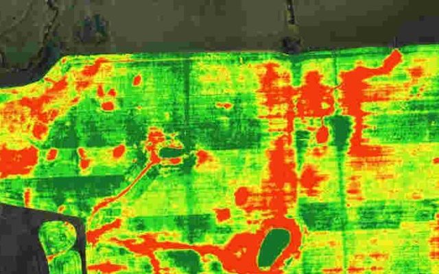
Enter the drone and big data solution. Or orbit satellite and big data solution. This is already happening, although not at large scale. Drones can autonomously fly at low altitude, equipped with special purpose cameras, and register a host of spectral information that once analysed can deliver powerful insight on the status of crops. Spectral information is used to understand if the growth of plants is normal, if temperature and watering is OK, and many other information. Digital image processing also helps counting the number of plants per square feet, giving information on the expected yield of the crop. All the images captured are relayed in real time to big data crunchers that with proper model return colored maps of the fields, helping the farmer to spot troubled areas and giving indications on potential causes and solution.
Now imagine a drone flying at low altitude, like a Delair, at a speed of 50km/h, covering an area of a 50,000 hectares at 12cm resolution in an hour, continuously taking pictures, and all of a sudden you are talking about GB/hr of data to be analysed. You have 1bn hectares of farmland just in US alone, and this should be monitored pretty frequently. Call it 3 times a week, to be on the low end. And all of a sudden you are talking petabyte of data that needs to be transferred, stored, mined, analysed, interpreted and spit out in a comprehensible way.And in a very useful, digestible, intuitive and actionable way. This is pretty big data, but the results, from initial experiments, seem to be crop yield increase anywhere between 10 to 20%.
In the last 60 to 70 years, crop yields in US have grown from a megre 0.1% a year (wheat) to 2.3% per year (corn). Imagine being able to add 10 to 20% in ten years (assume it will take 10 years for a full deployment of agricultural drones). And all of a sudden, you have doubled yearly crop yield growth. And this is just the beginning.
Article by channel:
Everything you need to know about Digital Transformation
The best articles, news and events direct to your inbox


